
September 03 - [11.6 Miles/11.6 Total] Canadian border to Jay Camp. This was my first
day on the trail. I actually traveled an additional mile or so on the Journey's
end trail. Jay & Camille, the good folks at Rose Apples Acres Farm B&B, droped me off at
the trailhead. I spent the night with several folks at Jay Camp including Turtle (Ron)
and a woman named Sue (Later Lost & Found). Both of these hikers later became
friends I would encounter repeatedly for more than half the hike. I also passed
another hiker named Pete hiking with his brother. Pete also turned up again later
in the hike. (See Sept 8)
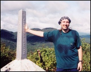 |
Canadian Border
Me (Snail-No-More) at the Canadian border. I'm actually standing in Canada
in this picture after entering the coutry illeagally. (Don't tell anyone!!) This is line post
592 placed here in 1907. I was surprised to discover that the border line shown on maps physically
exists. I could look off in both directions and see the border cut through the trees. |
|
September 04 - [11.7 Miles/23.3 Total] Jay Camp to Tillotson Camp. This was a gruelling
day of hiking. I averaged about a mile an hour through this tough tarrain. I also discoverd
on this day that I was short on food having only one dinner left! This meant I had to make
town in two more days of hiking or go hungry.
|
September 05 - [12.0 Miles/35.3 Total]
Tillotson Camp to Basin Brook. This was a tough and miserable day. I
found myself wishing to go home serveral times. I knew I had to do the
miles or go hungry which made it that much worse. I had inteaded to
make it to Corliss Camp but I was too tierd to make it. I stopped at Basin
Brook, three miles shy of the shelter, and set up my tent.
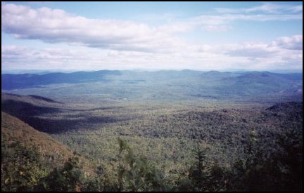
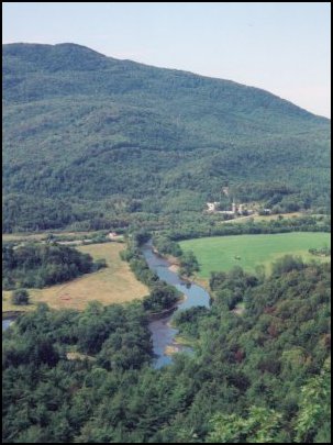
| View From Ritterbrush Lookout
I took a good long break at this beautiful spot. It was the ocassional
view like this that kept me going during the early days of this hike!
|
 |
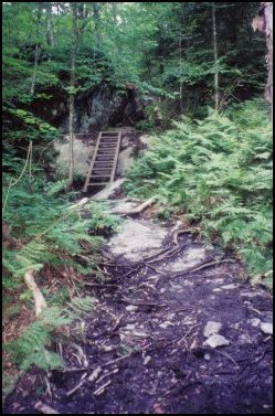 |
Devil's Gulch
This interesting bit of trail was toward the end of the day. I am not
going to claim the entire northern part of the Long Trail looks like
this but much of it actually did. After several days of hiking I was in
such disbelief that the trail could be so tough so I took this picture to
defend myself when describing the northern Long Trail to my friends.
Later in the hike I took another picture of the trail to show the
southern Long Trail. (See Sept 18)
|
|
September 06 - [10.2 Miles/45.5 Total] Basin Brook to Awesome View Hiker Hostel; Johnson, VT
I was so happy to reach this hostel, especially since I was out of food! I got
off the trail at Plot Rd rather than go all the way to Rt 15. This cut off around
4 miles from the days hike. I was able to pick up some extra food (Alpine Air!) and
a knee brace from the hiker box which meant I could hike the next bit of trail with
no worries of food. I had also sent a food drop to the hostel which was waiting for
me when I arrived. All and all this was a great town stop though I did not see any
other hikers in town and I was alone at the hostel.
Laraway Lookout
From my journal talking about this view:
"The trail was difficult today but not nearly so depressing. This afternoon
I got the best view yet this hike. The sun was out and I was happy. I spent
an hour on that cliff simply being content."
|
 |
|
September 07 - [12 Miles/57.5] Johnson, Vt to Whiteface Shelter.
What a differenc a town stop can make! This was a great day. Here is part of the
journal entry I made at Whiteface shelter.
"Coming out of town I was going to stay at Bear Hollow to make it a
short day. I got there at 2:30 but there was a group of college kids there
on their freshman orientation. This was enough incentive to move on. From the
shleter I had a 2300 foot climb to complete before getting here. I set my mind
to it and did it. I found my rythm. This was the first climb this trip I felt
really good about. I am becoming a hiker again!"
 |
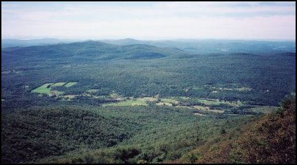
Prospect Rock
I had gotten off the trail at Plot Rd the day before which is 4.5 miles
before Rt 15 where most hikers get off for Johnson. I had actually considered
getting back on the trail at Rt 15 and just skipping the 4.5 miles. I
figured I would miss very little. Well in the end I felt like I had to do
that little piece of trail or it would bother me the rest of the hike. This
view is what I would have missed if I had skipped that 4.5 miles! In the
picture you can see both Rt 15 and the Lamoille river.
|
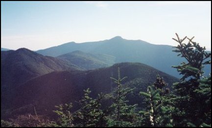
| View From Whiteface
The climb I am talking about in my journal entry above was up Whiteface
Mountain. Route 15 was at 500 ft, the summit of Whiteface where this
photo was taken is at 3715 ft. Quite a climb! This is also my first good
look at Mt Mansfields. (Background) The closer peak on the left is
Madonna Peak part of Sterling Ridge which I would climb up and over the
next day.
|
 |
|
September 08 - [8.1 Miles/65.6 Total] Whiteface
Shelter to Taft Lodge. This was a fairly short day. I arrived at the Lodge be 4:00PM
only to encounter yet another freshman orientation group. They were up there doing
trail work. Taft Lodge is the biggest shelter on the Long trail so there was
plenty of run for everyone. That evening both Pete and Turtle (Ron), both of whom I
met my first day out, caught up with me. I did not really know either very well
but just about any hiker reunion is a cause for celebration!
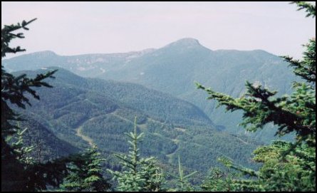 |
View From Madonna Peak
Here is another look at Mt Mansfield. By the evening I would be sleeping
at Taft Lodge not too far below the summit. This view is from near the summit.
|
|
September 09 - [10.2 Miles/75.8 Total] Taft Lodge
to Puffer Shelter. This was the day I went over Mt Mansfield. From my
journal:
"Wow what a day! I was on the trail by 7:30 AM, a first this trip. [...]
Turtle, Pete, and I got to the summit [of Mansfield] around the same time
which worked out great for photos. The summit was spectacular! Views in every
direction, clear sky, no wind, and a moderate temperature. We had the summit
to ourselves the whole half hour we were up there."
Later that day just after I arrive at Puffer Shelter two southbound AT thru hikers
showed up for a break. Yes, I said southbound AT thru hikers. They were going north
on the Long Trail. Their names were Black Forest and Cutter and they had started
their hikes at Katahdin, hiked south to Maine Junction, and turned around and
headed north on the Long Trail. Cutter explained to me that after the Whites they
wanted more above tree-line hikeing and the Long Trail would deliver that. Black
Forest also explained that when they got to Canada they were going to go party
in Montreal for a day or two before resumeing their southbound AT hike. To me
this was most likely the stronger reason!
| Approaching The Summit of Mansfield
This picture I took from the summit looking down the Long Trail northbound
from where I just came. If you look closly you can see friends Pete & Turtle
making their final approach to the summit.
|
 |
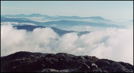 |
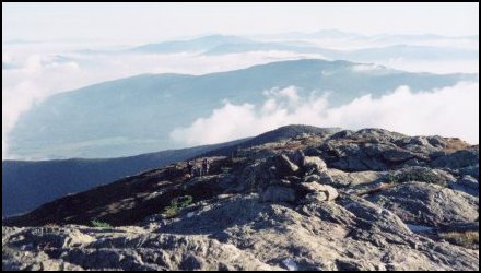
View From Summit of Mansfield
The view from here was spectacular. The sky was perfectly clear but clouds
had settled in the valley. The effect of this was quite beautiful as you
can see here.
|
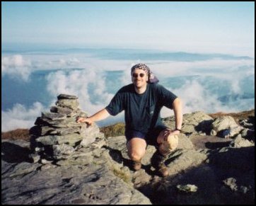
| Snail-No-More On The Summit
Here I am on the summit of Mt Mansfield. This was the high point of
my trip, literally, being the highest point in the state of Vermont.
This also happen to be my 22nd state high point. You can see other state
high points I've done on my State High Points page.
|
 |
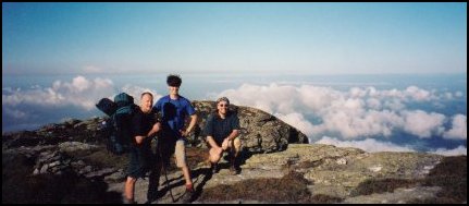 |
Very Near the Summit of Mansfield
A few hundred feet off the summit we realized we had not taken a group summit
photo. We decided this was close enough to the summit to count. Pictured from
left to right is Turtle, Pete, and me (Snail-No-More).
|
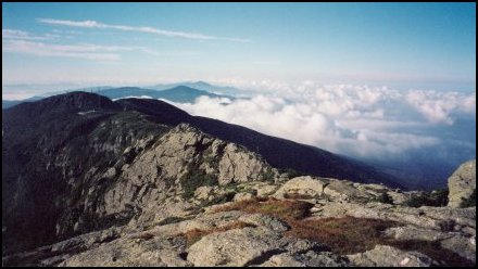
| The Mansfield Ridge
This picture was taken from near the summit looking south along Mansfield's
ridge line and the Long Trail toward the summit visitor's center and the
southern peak.
|
 |
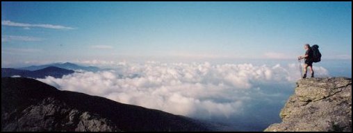 |
Snail-No-More Standing on a Rock Outcrop
This was also taken near the summit of Mansfield. Pete decided to check out a
rock outcrop slightly off the trail. I saw him standing up there so I took a photo
of him. Turtle decided that it was such a good photo op that he wanted one of
himself in the same spot. I of course couldn't resist the temptation myself so
I had Pete take a photo of me standing up there too. This is that photo.
|
|
|
Send Comments To
khoffman AT computer.org
Last Updated on October 27, 2000
|